


 The Ngarkat (SA) (pronounced Narr-kat) and the Wergaia (north-western Victoria) Aboriginal people originally inhabited the area prior to Europeans. Edward John Eyre was probably the first white man to visit the area in 1838. Explorers and squatters initially disliked the mallee because it contained little water or grass for stock. Therefore, the land in the Murray Mallee region with access to the Murray River floodplain was first used for sheep grazing. In the 1870s, the Mallee took on enormous value when considered as an extensive farming system for cereal crops.
Large scale Mallee vegetation clearance schemes rapidly followed. Charles Mullens developed a crude but effective technique for cleaning large areas of mallee scrub for wheat growing. This enabled mallee land to be profitably utilised by greatly reducing the expense of clearing. In 1913-14, the completion of railway lines led to the main period of settlement in the Murray Mallee region. The 1920s were the major period of vegetation clearing and development, and wheat growing was the main enterprise.
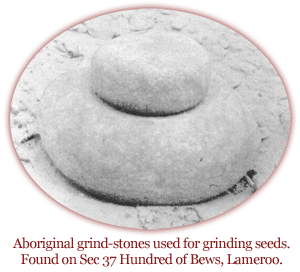
1838 - The first inhabitants of this mallee region were met by Edward John Eyre. He called them the 'Ngarkatko' and it is from these people that the Ngarkat Conservation Park gets its name. There being no permanent surface water, the Ngarkat were small in number and moved about widely depending upon seasonal conditions.
1849 - Victorian - South Australian border was surveyed, Australia's first surveyed border. A netting fence was built some 30 years later, though a legal dispute between the States about discrepancy in the position of the border continued until 1914.
1870's - Pastoral access to the eastern parts of SA was made easier after the bridge was built across the Murray River.
1871-76 - An early pastoral lease was taken out by John Whyte which extended from Tailem Bend to where Parilla stands today. He sank many important pioneer wells, fenced and stocked the country. He built a stone woolshed with 32-stands, which still exists just north of the Mallee Highway at Moorlands.
1890's - All mallee pastoral runs were severely affected by drought, rabbits, wild dogs, and a depressed economy in the 1890s.
The holdings were deserted, and by 1900 had reverted to Crown Land.
1885 - The next push for settlement of the mallee was driven by SA's need to find more wheat growing land. GW Goyder had surveyed the eastern mallee and believed it suitable. However farmers could not afford to clear land to plant crops without transport infrastructure to get produce to markets. SA Parliament debated the construction of a railway through the mallee for ten years, as never before had a railway preceded settlement and finally a railway line between Tailem Bend and Pinnaroo was built.
1906 - Railway finally opened being built using second hand rail and no ballast.
1906-12 - A huge influx of people came to the mallee to try their luck, either as farmers, workers or traders. As farms developed across the mallee, small towns grew up around rail sidings. Schools, local halls, shops, churches and sporting grounds were built, often with volunteer efforts. The main phase of agricultural development only took 25 years. The mallee underwent an incredibly rapid rate of settlement, despite this period also having one of the worst recorded droughts (1914), the First World War and the Great Depression.
1980's - The irrigation industry was attracted to the mallee, with cheap land available and the vast Artesian Basin beneath. Then in the late 1980s the population across the district declined markedly due to a severe economic downturn Australia-wide, which coincided with the scaling back of government services in mallee towns, and cereal farms were increasing in size to remain viable.