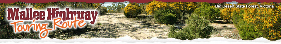


 Mallee Parks ~ South Australia
![]() This information has been supplied by the
This information has been supplied by the
Department of Environment and Natural Resources
For Access Conditions, times and permits
(08) 8204 1910 ~ www.environment.sa.gov.au
'South Australia’s Mallee Parks are hidden from the major highways in the area. However, for those wishing to experience a uniquely Australian environment, the mallee is well worth a visit.'
- Nature & Wildlife
• The Mallee Landscape
• Watching Wildlife
• Mallee Flowers
• The Honeydrippers
• The Precious Mallee Fowl
• 4 Wheel Driving
• Visitor Information - South Australian Mallee Parks
• Ngarkat Conservation Park
• Box Flat
• Pertendi Hut
• Pine Hut Soak
• The Border Track
• Baan Hill
• Billiatt Conservation Park
• Karte Conservation Park
• Peebinga National Park
• Parks Code
• Tracks of the Mallee - Victorian Mallee Parks
• Big Desert Wilderness Park
• Wyperfeld National Park
• Murray-Sunset National Park
• Pink Lakes
• 4WD in Victoria Parks
• Fire Safety
• Traditional Owners
• Track Classifications
This unique and very special part of our state has a network of more than a dozen stunning parks. These protected areas range in size from the huge 270 000 hectare Ngarkat Conservation Park to smaller areas such as the 3500 hectare Karte Conservation Park. This network combines with numerous privately owned patches of natural bushland to help conserve the ecologically rich mallee ecosystems.
South Australia’s mallee region has a diverse range of fascinating and unique wildlife, from the secretive pygmy-possums living in the banksia heaths to the rare Malleefowl. Ngarkat is home to more than thirty rare and endangered plant species. These plants help to produce a magnificent display of native wildflowers, particularly in spring.
The mallee region is steeped in history. The Ngarkat (pronounced Narr-kat) Aboriginal people originally inhabited the area, and evidence of their occupation still exists. The remnants of early attempts to graze stock in Ngarkat can also be found throughout the park. Among the intriguing historical sites are several ruins such as Box Flat and Bucks Camp. The restored wood-lined Nanam Well highlights the difficulties of obtaining water in this area. Opportunities to explore this region are endless. Those who take the time to experience the sights and sounds of this special place will discover ‘the secrets of the mallee’.
South Australia's Mallee Conservation Parks
Ngarkat Conservation Park (more information)
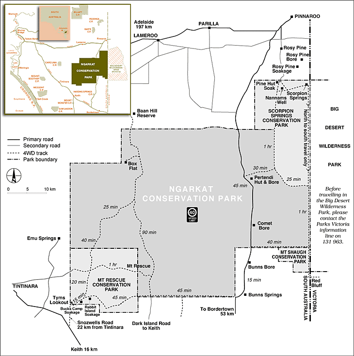 Ngarkat Conservation Park covers a total of 270 152 ha. The park consists of Mount Rescue, Mount Shaugh and Scorpion Springs, which join on to Ngarkat. In the park 22 kinds of reptiles have been recorded, 120 bird species, many types of mammals and plants are also contained within the park.
Locations of the various parks making up Ngarkat are:
• 24 kilometres south of Lameroo
• 34 kilometres south-west of Pinnaroo
• 30 kilometres south of Parrakie
• Mount Rescue - 18 kms east of Tintinara
• Mount Shaugh - 69 kms north of Bordertown (access very limited)
• Scorpion Springs - 20 kms south of Pinnaroo
• Four-wheel drive vehicles are recommended for the park due to the many sandhills.
It is also recommended that you visit during the cooler months and that you carry ample fuel and water supplies.
Box Flat - a peaceful seclusion (more information)
Box Flat is a favourite camping spot for many local families. Several camping sites are available ensuring visitors a peaceful respite and a quality wilderness experience. An oasis in the wilderness, Box Flat fulfils an important role in the ecology of the sensitive mallee environment. With the opening rains falling between April and June, this area is transformed into a lush haven for wildlife. The flush of new growth provides an important food source for grazing animals, and a breeding area for waterbirds.
Pertendi Hut (more information)
Part of the Ngarkat Conservation Park and maintained by the South Australian Department for Environment and Heritage.
Entry: Approximately 45km south of Mallee Highway on the Pinnaroo to Bordertown bitumen road, it is well signposted.
Walk: Easy walking trail which is very prety in spring-time
Explore: Historic Sheperds Hut
Facilities: Toilet, water, picnic tables, campfire, campsites (permit required by self registration at site)
Pine Hut Soak (more information)
Part of the Ngarkat Conservation Park and maintained by South Australian Department for Environment and Heritage.
Entry: 15km down gravel Rosy Pine Road which comes off the Mallee Highway approximately 6km south west of Pinnaroo
Walk: A network of walking trails
Facilities: Toilet, water, picnic tables, campfire, campsites (permit required by self registration at site)
Walking – Self-guided walks, such as those at Tyms Lookout, Pertendi Hut, and the trail from Pine Hut Soak to Scorpion Springs and Nannams Well is a great way to experience the mallee. Great views can be found after short walks to the top of Mount Rescue, Gosse Hill and Mount Shaugh. (Walking information)
Camping – Camping is permitted at six sites within the park and fees apply. Box Flat, Pine Hut Soak, Pertendi Hut, Comet Bore, Bucks Camp and Rabbit Island are the designated areas. (Camping information)
Remember that these are important drinking spots for kangaroos, emus and birds, and are home to many elusive, small nocturnal animals, Thank of other campers and bury toilet waste deep - at lease 30cm. Take your rubbish with you and leave generators and loud music at home. Enjoy the sounds of the bush instead!
Birdwatching – For the birdwatcher, Comet Bore and Rabbit Island have the greatest diversity of species. Yellow-tailed black cockatoos, mallee ringneck parrots, thornbills and mallee fowl are just a small sample of what can be found in the park.
Visiting the parks – The best times to visit are late autumn, winter and early spring. Summer is not recommended because of high temperatures and risk of fire. You will need to carry your own water, plenty of food and fuel, and have a mechanically sound vehicle. Useful additions include a tyre pump/compressor, tyre gauge and shovel. We encourage you to bring your own firewood, as fallen wood in the park provides shelter for many native animals.
Fire restrictions apply from 1 November to 30 April. During this time only gas fires are permitted, with the exception of total fire ban days, when no fires are allowed.
Driving in the parks – Access to most of the parks requires a 4WD vehicle due to the sandy conditions. For better traction, and reduced damage to tracks, recommended tyre pressures are 18-22 psi or 120-150 kpa (about half that used when driving on sealed roads). A speed limit of 40 kph has also been set.
Be aware of oncoming vehicles and pedestrians which may be on the tracks. Please travel in the existing wheel ruts and don’t follow or create new side tracks. These green markers will guide you to the various points of interest. The estimated travel times between these points are shown on the map.
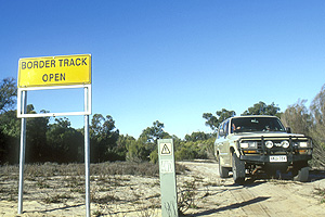
The Border Track
From the north-east corner of Ngarkat Conservation Park, the Border Track runs one-way - north to south. At the junction of the Border Track and the Centre Track (approx. 29km down the Border Track), the track reverts to a two-way system. The one-way system has been implemented to protect the sand dunes, track surface and vegetation. The Border Track presents extremely difficult driving conditions. If you are not fully prepared, and supported by other vehicles, don't go. The Border Track is closed throughout the fire season. Please use an alternative route if travelling through the park during this time. Moderate rain can flood the track for a number of days. Avoid using the track during and after heavy rain.
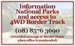
Border Track and Parks Information
Mallee District National Parks & Wildlife SA
– Lameroo Office
For Ngarkat, Billiatt, Karte and Peebinga Parks.
Phone: (08) 8576 3690
Baan Hill (more information)
Baan Hill is just outside Ngarkat Conservation Park and is maintained by the Southern Mallee District Council and the Lameroo Rotary Club. Signposted on Mallee Highway and is accessed by dirt road but 2WD accessible approximately 20km south-south west of Lameroo. It is a gravel road and the entrance into the picnic site is jut before the entrance to the park.
Walk: There are no set walks but you can explore among the sand dunes and large gums around the site.Very pretty in spring time. Explore Mrs Monru's home site.
Facilities: Large shaded area with ample car parking. Large sheltered shed with fireplace. Toilets and rain water available. Covered picnic table.
Billiatt Conservation Park is situated 18 km south of Alawoona on the main Alowoona Lameroo road that meets the park's southern boundary 37 km from Lameroo. The park is only sign posted on the north-eastern corner. Ample water and fuel should be carried when travelling in this area. The country is characterised by sand dunes with a mosaic of open Mallee scrub. Ridge-fruited Mallee and Red-tipped Slender Leaf Mallee add colour to the dunes while Broom Brush grows in the mottled shade. Excellent views can be obtained from the Trig Point by walking 1 km from the road. This is not sign-posted.
On the dunefields in the cntre of the Murray Mallee district, this park supports a mosaic of open mallee scrub. The chunky fruit of the ridge-fruited mallee and the red tips of the slender-leaved mallee and colour on the dunes while in the swales broombush grows in the mottled shade. In the umbrella-like canopy, pygmy-possums have been seen, and many birds, including the rare western whipbird and the red-lored whistler, sing a fed among the whipstick trunks, Malleefow scratch in the leaf and bark letter. The rare small marsupial Ningaui was collected here for the first time in 1973.
The park is 18km south of Alawoona and 37km north of Lameroo. The main Lameroo-Alawoona road (unsealed, all weather) meets the park's southern boundary 30km from Lameroo and passes through the park which is signposted only at its north-eastern corner.
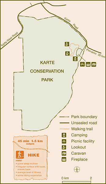
Karte Park Map
Karte (pronounced Kartee) Conservation Park is located 30 km north-west of Pinnaroo. The word Karte is an Aboriginal word meaning thick, low scrub. The park protects 3565 hectares of mallee vegetation, primarily to provide habitat for the threatened Malleefowl.
In 1988, Pinnaroo Area School students, as part of a Bicentennial Project, constructed a walking trail. The Friends of Southern Mallee Parks adopted the trail and now help to maintain it.
Starting from the picnic area, this trail forms a 1.5 km loop and takes about 45 minutes to complete. There are some steep sections that require a reasonable level of fitness. Take time to read the signs along the trail that explain a little about the importance of the vegetation in the area. There are picnic facilities and camp sites located near the start of the trail.
Throughout the park there are a series of steep sand dunes rising up to forty metres. During the early part of the twentieth century much of the land in the area was cleared for agriculture. The area that is now Karte Conservation Park was left uncleared as the sand dunes were unsuitable for agriculture. As you follow the walking trail, you will be rewarded with views of the surrounding district. There are a number of smaller, isolated dunes with the original vegetation still present. This vegetation has been left to avoid erosion and loss of agricultural land.
The vegetation in the park provides habitat for the endangered Mallee Whipbird, and a number of rare orchids. More than forty species of bird call this park home.
Peebinga Conservation Park was reserved to conserve the habitat of the rare Western Whipbird. The park is situated 37 km north of Peebinga. Access is from the Pinnaroo Loxton Road via the Kringin turnoff. An unsealed road located 3 km west along the Kringin Road turns south opposite "Mootatunga" and cuts through a section of the park.
There are signposts at Kringin and at the Mootatunga turn off. Caravans can access from the Mootatunga end but ample fuel and water should be carried at all times.
Vegetation in the park varies as some of it has been cleared and remains grassland. The rest is characterised by low stabilised dunes with open scrub cover featuring Ridge-fruited and Slender-leaved Mallee with Warty Cypress over Broom Bush. The higher areas have Square-fruited, Red and White Mallees. As well as the Whipbird, the park has Malleefowl, Western Grey Kangaroos and Echidnas.
Parks of the Mallee and bush code
The mallee is one of South Australia's most characteristic landscapes. Vast gently undulating plains, intersprersed with dunes, and covered with a 'sea' of the slender trunks and spreading canopies of mallee eucalypts, were what the early European explorers and settlers found here.
To protect this area please follow the Australian Bush Country Code:
Drive carefully : keep to roads and tracks
Consider local people : respect their property and stock
Leave no litter : take your rubbish home
Think of others : avoid being noisy
Respect the past : leave old things as you find them
Care for our native plants and animals : respect their habitat
Safeguard water : don't waste it, keep it clean
Take care with fire : wildfires destroy
Firearms : are not permitted in the parks
Think safety : take care of yourself and others
Help protect your national parks by following these guidelines:
• Leave your pets at home
• Take your rubbish with you
• Observe fire restrictions, usually 1 November to 30 April.
• Check CFS hotline 1300 362 361. Gas fires only during this period except on days of declared Total Fire Ban.
The parks are covered by the Riverland, Murraylands and Upper South East fire ban districts.
• Conserve native habitat by using liquid fuel or gas stoves
• Camp only in designated areas (more information)
• Respect geological and heritage sites
• Keep our wildlife wild - do not feed or disturb animals, or remove native plants
• Keep to defined vehicle tracks and walking trails
• Be considerate of other park users
• Generators and firearms are not permitted
• Maximum speed limit in parks is 40 km per hour.
Thank you for leaving the bush in its natural state for the enjoyment of others.
South Australia’s Mallee Parks are hidden from the major highways in the area. However, for those wishing to experience a uniquely Australian environment, the mallee is well worth a visit.
This unique and very special part of our state has a network of more than a dozen stunning parks. These protected areas range in size from the huge 270 000 hectare Ngarkat Conservation Park to smaller areas such as the 3500 hectare Karte Conservation Park. This network combines with numerous privately owned patches of natural bushland to help conserve the ecologically rich mallee ecosystems.
South Australia’s mallee region has a diverse range of fascinating and unique wildlife, from the secretive pygmy-possums living in the banksia heaths to the rare Malleefowl. Ngarkat is home to more than thirty rare and endangered plant species. These plants help to produce a magnificent display of native wildflowers, particularly in spring.
The mallee region is steeped in history. The Ngarkat (pronounced Narr-kat) Aboriginal people originally inhabited the area, and evidence of their occupation still exists. The remnants of early attempts to graze stock in Ngarkat can also be found throughout the park. Among the intriguing historical sites are several ruins such as Box Flat and Bucks Camp. The restored wood-lined Nanam Well highlights the difficulties of obtaining water in this area. Opportunities to explore this region are endless. Those who take the time to experience the sights and sounds of this special place will discover ‘the secrets of the mallee’.
Department of Environment and Natural Resources
- Nature & Wildlife
• The Mallee Landscape
• Watching Wildlife
• Mallee Flowers
• The Honeydrippers
• The Precious Mallee Fowl
• 4 Wheel Driving
• Visitor Information - South Australian Mallee Parks
• Ngarkat Conservation Park
• Box Flat
• Pertendi Hut
• Pine Hut Soak
• The Border Track
• Baan Hill
• Billiatt Conservation Park
• Karte Conservation Park
• Peebinga National Park
• Parks Code
• Tracks of the Mallee - Victorian Mallee Parks
• Big Desert Wilderness Park
• Wyperfeld National Park
• Murray-Sunset National Park
• Pink Lakes
• 4WD in Victoria Parks
• Fire Safety
• Traditional Owners
• Track Classifications